Services
Dingo Prospecting specializes in early-stage exploration, providing a streamlined and cost-effective solution to help companies meet their annual expenditure requirements while acquiring high-quality exploration data efficiently.

Rock Chipping
Ideal for gathering geochemical data to identify areas with potential mineralization, including gold, copper, lithium, and other valuable resources.
Programs are customized for each exploration project and targeted resource.
Programs usually consist of:
Rock Chips 2-3kg each
Unique sample ID
Photograph of each sample taken
GPS location
Brief description of sample taken
Excel Document with the above
Chip tray with representative sample labelled for office use
QGIS map with rock sample locations

Soil & Stream Sediment Sampling
Ideal for detecting subsurface mineralisation and pathfinder elements. Helps to define geochemical anomalies and alteration zones.
Key aspects to consider:
Mesh size (Usually -2mm, -180 µm (80 mesh) or -250 µm (60 mesh)
Terrain
Surface cover and related transport processes
Number of samples
Spacing between samples
Sample weight (typically 250grams)
Best practices (e.g. duplicates, quality control, soil horizon selection)
Drone Mapping
Dingo Prospecting offers targeted custom solutions for aerial mapping of your tenement.
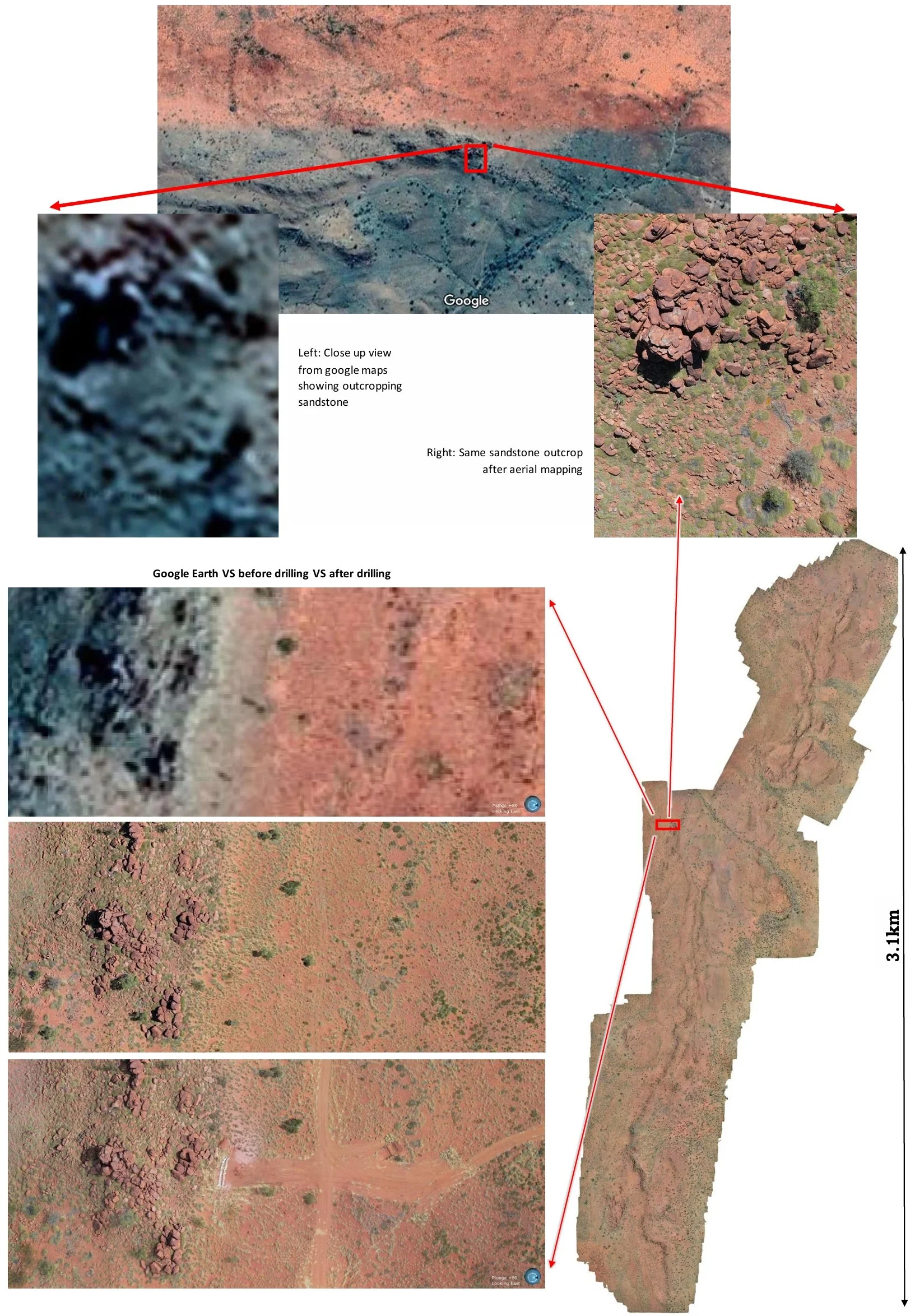
Google Earth vs Elevation Model vs High-Res Map

Ideal for
Planning drill pads
Planning access tracks
Heritage surveys
Locating outcrop and interpreting structures
Showing more accurate elevation changes
Recording ground disturbance and environmental data
Avenza, QGIS, Leapfrog and similar GIS software
Printed Maps
Cross validation of recorded drill hole locations with up to date imagery
Identifying pads not drilled or made
ASX announcements
Showing Clients
Up to date high resolution imagery is an invaluable resource for any modern-day drill program.
Below: cross section of a drilling program showing drill hole traces using google earth imagery and topographic data vs Dingo Prospecting high-res drone imagery and topographic data
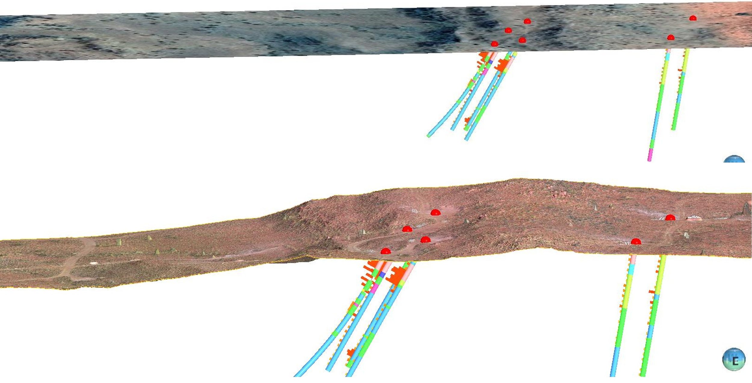
Comparison Google Earth Vs Drone Imagery
Below: Identify ground disturbance, bags left on pad, access routes as well as incorrect GPS hole locations. Red circle indicates where the hole was drilled however the recorded GPS location (red dot) is showing the hole 25m further away in the wrong location. This is a common occurrence and something that is not often picked up on by many exploration companies.

Case Examples
Identifying Untested Quartz Veining
High-resolution drone imagery revealed linear parallel quartz veining outcropping in an area that had not yet been rock chipped. A follow-up field excursion confirmed this discovery, returning some of the highest anomalous results seen in the program.Correcting Drill Hole Coordinates
Collar files, survey data, and geology were entered into Leapfrog, identifying a shear zone. However, georeferenced aerial mapping revealed that several drill hole coordinates were incorrect, as their plotted locations did not align with cleared pads. These corrections adjusted the shear zone's dipping angle, ultimately refining infill hole locations and planned drill depths.Avoiding Inaccessible Terrain for Drilling
A drill program with 50m spaced holes was designed from your Perth based office. Preliminary high-resolution drone mapping showed that many planned holes were located in steep, inaccessible terrain. Adjustments were made to optimize drill locations, saving time in the field. Later, when a gap in the drill data was noticed, a quick review of aerial imagery confirmed the location was inaccessible, leading to a new, feasible drill site.Identifying Historical Work
Your area has been previously explored and drilled. Accurate up to date imagery can identify existing tracks which can be beneficial for any PoW application. A lot of drilling occurred when GPS was poor or non-existent, however their ground disturbance remains to this day. A high-resolution map can help locate these old holes which can be important when drilling due to the potential of old hole activation.Enhancing Investor Engagement
Show investors a clear and compelling view of your project area using high-resolution imagery. A combination of flyover videos and geological snapshots can generate greater interest in your project.Structural Interpretation for Mineralization
Numerous faults and an unconformity run throughout your project, potentially acting as key structural controls for mineralization. High-resolution mapping helps accurately identify these critical geological features.Minimizing Environmental Impact
When working in environmentally sensitive areas, precise mapping enables track planning that avoids major bushlands and trees. A follow-up survey along the same flight paths can then document the actual impact, providing a valuable assessment of environmental impactField Navigation & Pegging with Georeferenced Imagery
Clearing tracks and pegging drill holes can be streamlined using high resolution drone imagery. These maps can be uploaded into Avenza Maps, allowing field teams to navigate efficiently to areas of interest.
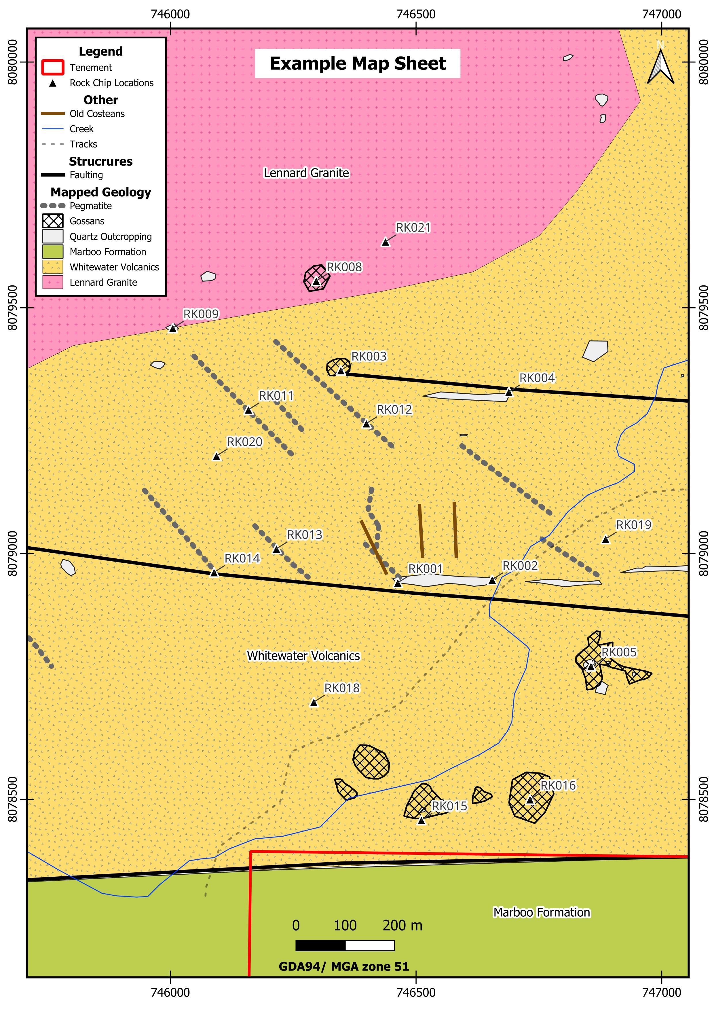
Geological Mapping
In conjunction with field rock chipping and soil sampling programs, geological mapping can be conducted with a focus on target mineralisation, alteration, structures, and stratigraphy, enhancing geological understanding of the area.
Mapped outcrops will be presented as a digitised QGIS layer file, similar in style to the example shown below. Mapping, rock chips and soil samples can be overlain onto Google Satellite and high-resolution drone imagery.